The same software that was once used in military aerospace operations is now being deployed to measure and manage soil productivity.
Innovative Armidale-based agtech startup FarmLab has seized the opportunity to marry its expertise in providing aviation solutions with the needs of Australian farmers.
Soil is a fundamental resource for grain production, so if we are better-informed about its productive capacity, we can drive better grain performance. But there is a lack of digitisation of soil data and most soil samples are not geo-referenced to log spatial variation.
With experience serving in the Royal Australian Air Force and a keen interest in agriculture and startups, Sam Duncan’s focus shifted to agtech, which led to FarmLab, a solution to this very challenge – an easy-to-use environmental measurement software.
“The lack of digitised and geo-referenced soil samples was hindering farmers’ ability to make decisions about yield limiting factors and nutrient applications,” says Mr Duncan, the chief executive and co-founder of FarmLab.
Founded in 2016, the business was initially based on a mobile app to help agronomists barcode soil samples. “We partnered with some of Australia’s leading laboratories back then – Environmental Analysis Laboratory (EAL) at Southern Cross University and APAL in Adelaide. Our clients would send them samples, and the labs would send us the results for us to map for our clients,” Mr Duncan says.
FarmLab co-founder Shahriar Jamshidi, who is chief technical officer, had developed the software for an aviation company to track and record while in mid-air the offload of fuel.
“This taught us a lot about getting the software to work offline, or in comms-degraded environments – perfectly suited for Australian agriculture. We took that architecture and developed the first version of the mobile app for FarmLab.”
Support to grow
FarmLab received investment from GrainInnovate in 2020 after participating in the SproutX Accelerator program in Melbourne.
“We saw it as a critical step because it gave us strategic support from the industry. It helped us validate the idea and knowing that GRDC was supportive of FarmLab meant we knew we were solving a valid problem,” Mr Duncan says.
He says the innovation develops auto-generated soil test reports for agronomists and they are now experimenting with artificial intelligence to help write reports based on soil test results.
FarmLab now covers about 2000 farms across Australia and has 20,000 soil samples planned for 2023. The team is working with growers to help them enter the emerging environmental market space using measured soil data.
“We have been working closely with the Clean Energy Regulator to develop its soil carbon legislation into FarmLab. This means that project managers and farmers can use FarmLab to measure soil carbon in line with Australian government legislation – which is considered one of the highest standards for soil carbon measurement in the world.
“We’re also working with GRDC to commercialise the ConstraintID tool to help growers identify subsoil constraints across paddocks and integrate these into FarmLab to support assessments with on-ground measurements.”
FarmLab automated agronomic report.
Soil carbon measurement is being bolstered further as FarmLab and its partners have received $8.4 million in round one of the National Soil Carbon Innovation Challenge grant in 2022.
“In addition to this, we’re building capacity in the US with ranchers and growers to support them to collect soil samples and measure soil using FarmLab. This has demonstrated that the work we’ve been doing in Australian agriculture is cutting-edge.”
Case Study: Tech and science merge for visual production analysis
Penny Frederiksen farms ‘Glen Vale’, a 150-hectare grazing and dryland cropping property near Warwick on the Darling Downs in Queensland. She was interested in understanding more about the health of her property’s soil – in particular the carbon levels which are critical to productivity and sustainability.
To gain insights into these factors, FarmLab partnered with VRM Biologik, a local agronomy and inputs business, to assess soil carbon and biodiversity on ‘Glen Vale’.
The goal was to develop an overview of production drivers and current carbon levels on ‘Glen Vale’ for the land manager, and use soil tests as the basis for this analysis.
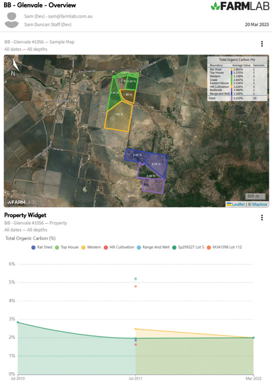 FarmLab automated agronomic report. Source: Farmlab
To achieve this, FarmLab developed a desktop estimate of carbon for the property. This provided an initial assessment of soil carbon using a licensed version of the CSIRO's LOOC-C tool. The report predicted current carbon levels of 1.7 per cent with maximum levels in the region estimated at 4.8 per cent.
To further optimise the sampling process, VRM Biologik used FarmLab to look at recent productivity based on vegetation indices across the property. This helped identify areas where soil was not performing optimally and was used to strategically determine locations for sample collection.
Paddock history, with more focus on cropped paddocks than grazed ones, and proximity to strata were key factors considered in determining sample locations. The Fredericksens were consulted for feedback on the strata and sample plan prior to conducting the sampling.
Using the FarmLab mobile app, Clinton Buck from VRM Biologik collected samples at 10 pre-determined locations on ‘Glen Vale’. At each site, photos were taken and notes were entered in the app to capture field conditions and relevant sample information. FarmLab was used to quickly create additional data collection fields to estimate biodiversity and soil texture.
Personalised sample labels were provided by FarmLab to improve accuracy and reduce time taken when logging the soil data.
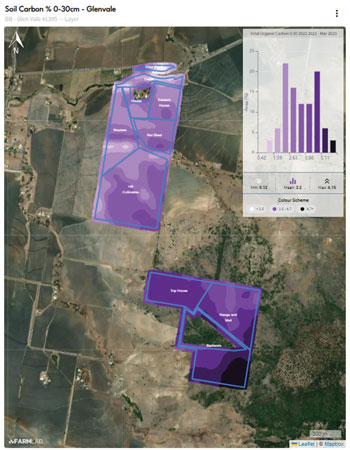 A soil map automatically generated for Glen Vale from soil test results using FarmLab analytics. Source: FarmLab
Once the samples were collected, they were submitted to EAL at Southern Cross University for agronomic and carbon testing. EAL used the FarmLab portal to automatically upload and display results for the client.
“Like 65 per cent of the population, I’m a visual learner,” Ms Frederiksen says.
“Using the maps was particularly helpful in receiving and understanding the information gathered.”
Mr Buck says: “We were able to generate a highly accurate map using FarmLab.
“This helped us better understand and consult with our client on exactly where they lacked carbon, and the areas they could focus on to improve yield.”
More information: farmlab.com.au, sam@farmlab.com.au
