Efficiency, sustainability and farm profitability are top of mind for husband-and-wife team Tim and Peta Neale. Their passion for delivering user-friendly digital agriculture tools enabling growers to farm smarter, has been a feature of their extensive careers in agriculture.
The Neales are agtech pioneers who ventured into the sector 25 years ago, but more recently established DataFarming in 2017.
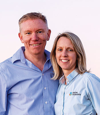
 Husband and wife team, Tim and Peta Neale have been stalwart advocates for the benefits that agtech can bring to farming enterprises. In recent years they have launched the startup DataFarming to assist growers in making more informed farming decisions. Photo: Datafarming
“We saw three main problems facing growers that DataFarming addresses: variability in production, lack of objective data for decision making, and low adoption of digital ag technologies,” Mr Neale says.
There can be 300 per cent variability in production within paddocks and most growers add the same rate of inputs across the paddock, which has economic and environmental implications.
DataFarming’s solution is a simple web-based platform – The Digital Agronomist™ – which combines a number of tools.
The master tool in the set is the provision of satellite imagery from the European Space Agency every five days for free. Every few days, satellites generate a new colour-coded picture of Australia with Normalised Difference Vegetation Index (NDVI) images. These images can be used by growers and agronomists to identify anomalies in paddocks, including weed hotspots, insect damage, soil type variation, disease outbreaks and water drainage issues. These can be valuable prompts to go and investigate further.
The company also offers value-added products such as high-resolution images, stacked satellite imagery that layers up to five years of imagery for one location, together with variable rate zone files. All this is powered by custom software based in AWS (Amazon Web Services).
Development support
DataFarming has worked collaboratively with commercial, government and academic partners, and is an integration partner with six other software companies.
Mr Neale says GRDC’s GrainInnovate programme has been instrumental in providing seed funding to help the business get started and develop, and, importantly, it has helped validate the business as the fund is industry backed.
“GrainInnovate is a fantastic and unique initiative by GRDC, and we certainly hope growers feel they have received good return on that investment in us,” he says.
DataFarming growth
“Software development is hard and finding good staff or agencies to support these developments is a challenge, especially when we choose to be located regionally in Toowoomba,” Mr Neale says.
Despite these challenges DataFarming has made incredible progress since its inception. The rate of adoption has been testament to the Neales’ focus on ensuring the platform is simple to use, low cost and easy to access.
“Before we came along, only four per cent of farmers had looked at a satellite image of their property. We have reached nearly 40 per cent of the market within five years,” Mr Neale says.
“That is around 35,000 farms, 170,000 fields, 18 million hectares of processed data. We have continued growing at around 110 farms a week since day one.
“We want to develop more products for Australian growers – from four current products to 10. This will help drive mass market adoption of precision agriculture tools so agronomists and farmers can benefit. Our anticipated development of automated tools will also assist growers to more easily meet sustainability requirements.”
Mr Neale says the company will stay regionally based in Toowoomba to ensure connection with growers, but it plans to expand globally.
Case Study: Return on investment drives digital adoption at Binginbar
The Simpsons have experienced many changes in farming technology over the 155 years the family has farmed ‘Binginbar’ at Gollan, between Wellington, Dubbo and Dunedoo in central NSW. Since 2016, Binginbar Farms has been implementing a digital transformation.
CEO Nathan Simpson says the family farms more than 4000 hectares with a 60:40 mix of cropping and pasture.

An aerial photo of a ‘Binginbar’ paddock where farm management practices are being better informed using satellite imagery and data layering through the adoption of DataFarming tools. Photo: Nathan Simpson, Binginbar Farms
Annual rainfall is about 550 millimetres, with 275mm growing season rainfall and crops are produced on a seven-year rotation. Dual-purpose wheat, canola and barley are grown in sequence with perennial pastures for finishing up to 70,000 lambs a year.
“We started using GPS guidance in 2007 and recording yield with yield maps in 2009,” Mr Simpson says.
“We then moved into documenting all our application records via MyJohnDeere.”
It was in 2018 that Mr Simpson started using DataFarming’s services.
Combining DataFarming’s offering with services provided by his agronomist, Hayden Hollis from Agricore, Mr Simpson has been building data layers of the property to inform management decisions.
Power of maps
“We have mapped paddocks for electrical conductivity which gives us a spatial picture of the soils’ composition – the amount of salt, sand, clay, organic matter and water content – across a paddock,” Mr Simpson says.
This can be layered or ‘stacked’ with elevation and topography maps, and NDVI maps generated by satellites, provided through DataFarming, enabling real-time decisions to be made in response to circumstances in the paddocks.
The top-down view provides a valuable perspective on crop and soil information that is not achievable at ground level. But the power is in using multispectral cameras such as NDVI which can capture reflectance from crops in the non-visible spectrum that helps identify crop anomalies not visible to the human eye.
“This means we can make better informed decisions on in-crop inputs such as top- dressing nitrogen, weed management and pest management,” Mr Simpson says.
Following harvest, further data layers that capture spatial responses in the form of crop yield across a paddock can be collected.
“Hayden is then able to generate a profit map for each paddock, which is essentially a gross margin map as a record of seasonal performance,” Mr Simpson says.
“It is these maps that we refer to at the start of each season to make much more informed decisions about our cropping program for each paddock.
Our use of this technology is all about improving efficiency and return on investment. If we can optimise inputs and target areas in paddocks where we get the best returns, we will drive profitability.
“If we can produce more biomass and therefore grain or meat with the same or arguably less inputs than a conventional approach, then the entire system becomes much more sustainable.
“The other side of this coin is if we can achieve higher plant production in a sustainable manner, this has the side benefit of being able to sequester more carbon into our soils, further adding to our production gains.”
More information: Tim Neale, 0409 634 006, insights@datafarming.com.au; Data Farming; Nathan Simpson, 0421 247 096, nathan@binginbarfarms.com.au, Binginbar Farms


