Key points
- The Yarrie Lake Landcare Group went on a study tour to Goondiwindi to see how melon hole country can be levelled
- MCA Agronomy organised the tour with support from the GRDC grower and adviser study tour program
- The advantages of levelling paddocks include increased production, more even water infiltration and improved operation timeliness
Already aware of the benefits of levelling melon holes, a group of growers went on a road trip earlier this year to see the process in action
When Rob Duncan read about how a fellow grain grower was addressing melon holes, he was interested in discovering more.
A call to an old friend, MCA Agronomy’s Paul Gardoll, ensued and before long he had applied to and received support for a GRDC grower and adviser study tour for the Yarrie Lake Landcare Group to see how other landholders were managing melon holes.
Mr Duncan, the chair of the Yarrie Lake Landcare Group, runs a 2000-hectare mixed farm south of Wee Waa, NSW. With his son, Christopher, he farms Angus cattle and crops seed oats, barley, canola and wheat.
He says the land around Yarrie Lake is an unusual mix of brigalow, with a high clay content, and sodic soils. Deep down, the pH levels are as high as nine.
Melon holes, naturally occurring depressions surrounded by associated mounds, are characteristic of brigalow soils. They can lead to nutrient and organic carbon leaching laterally and accumulating at the bottoms of the holes. This can, in turn, leave the tops bleached, infertile and unable to hold moisture.
Over the past five years, MCA Agronomy’s precision agriculture specialist Sam Castor has worked with growers around Goondiwindi, Queensland, to survey, map and level paddocks. Many growers have attempted this process over time (see breakout below).
Mr Castor helped organise the study tour and guided the Yarrie Lake Landcare Group to local growers at various stages of the levelling process.

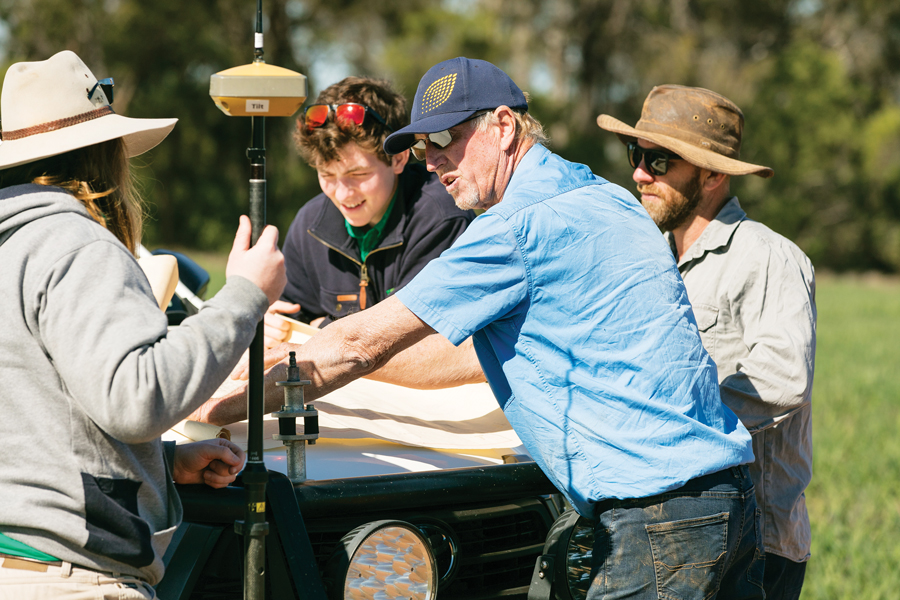
Rob Duncan from ‘Burradoo’ at Yarrie Lake (with the blue cap) with farm maps and neighbour Mitch Lewis (right) and CAD staff who are undertaking state-of-the-art mapping for amelioration of melon holes. Photo: Mel Jensen
What are the advantages of levelling?
Major advantages include increased production through reduced waterlogging and more even water infiltration.
With less water sitting in paddocks, bogging becomes less likely and, with that, an uptick in operation timeliness for planting, spraying and harvesting.
The process is undertaken over several years so that soil horizons are re-established incrementally.
While levelling does not lead to less sodic soils, some growers may apply gypsum to paddocks afterwards. This can be because some of the deep-cut areas expose deeper subsoils, which may have higher sodicity levels.
What are the options?
The first step is to undertake surveys and there are options to suit different budgets, Mr Castor says. “It is important to discuss what can be done for different budgets.”
Aerial LiDAR
Aerial LiDAR (light detection and ranging) surveys create detailed digital elevation maps, which can be used in various CAD (computer-assisted design) programs. Designs and control files can be developed to aid machinery in implementing earthworks.
MCA agronomists recommend this survey type because it allows large areas to be surveyed over a relatively short time.
“Since an entire farm can be surveyed, not just within a field boundary, drainage across the whole farm can be assessed and decisions made with a holistic view,” Mr Castor says.
LiDAR is not just relevant to relatively flat country. It is often used for soil conservation earthworks such as erosion repair and prevention in paddocks with steep slopes. It can also be used for irrigation design.
Real-time kinematic positioning
Another option is to use real-time kinematic positioning (RTK), available on tractors, to map the land’s topography.
“RTK tractor surveys typically have good vertical accuracy but only record elevation in swaths – generally down tramlines,” Mr Castor says.
This means that elevation between tramlines is not recorded and is, therefore, interpolated.
“From a levelling design, this can impact the reliability of earthworks statistics produced. RTK tractor surveys also generally record elevation with a field boundary, making it difficult to assess whole farm drainage.”
What next?
Those on the tour are already planning their next moves. Some have chosen aerial LiDAR surveys with complete designs, while others will use RTK to map their farms.
Mr Duncan has chosen to have Mr Castor and MCA Agronomy aerially survey the land and cost the options.
Before doing the job he loves most – farming – Mr Duncan used to drive earthmoving equipment like the laser buckets often used for flood irrigation in cotton. He found the detail generated by LiDAR surveys impressive.
“It is amazing. And the data generated is not just generated for the sake of it. The technology is all about accuracy.”
Despite his earthmoving background, Mr Duncan will use a contractor. “We don’t have good enough gear to level it ourselves. We will start by doing part of the farm – 250ha.”
It is currently sown to barley. “We’ll burn the stubble, plant canola and start moving the soil. We don’t want to move stubble, we want to move dirt, and canola does not leave a lot of stubble.”
The next step will be considering nutrients. Mr Duncan has been working with the University of New England’s Dr Ivanah Oliver on hostile subsoils (via a ConstraintID project).
“Levelling opens up the opportunity for us to apply phosphorous afterwards, but that is a strategic decision we need to make.”
Mr Duncan says these decisions are hard to make, especially after a tough year last year. “But it’s important to keep moving forward. Some parts of the farm have never been harvested because it is too wet.
“We don’t want to spend money on fertiliser and spraying and we need to do something.”
The Landcare group chipped in for a gift for the growers who spoke to them. “We also really appreciated what MCA Agronomy did for us. It’s been great.”
GRDC senior regional manager – north – Rebecca Raymond says GRDC’s grower and adviser study tours program is designed to raise awareness and build knowledge to support practice change at a farm level.
“Every year GRDC supports a number of grower and adviser study tours across Australia to different farming regions or research centres,” Mrs Raymond says.
“This program is part of our commitment to supporting capacity building. We know seeing how other landholders are dealing with issues or embracing opportunities is a really effective way for growers to improve their own farming businesses.”
The GRDC study tour program complements GRDC’s National Grower Network activities.

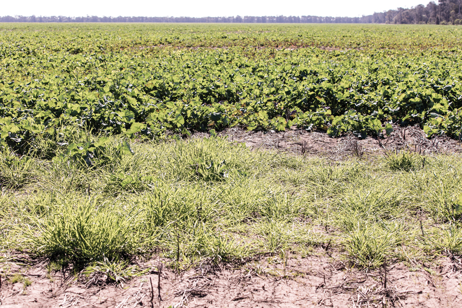
Rob Duncan's canola crop with weeds growing as a result of waterlogging and melon holes. Photo: Mel Jensen
Land prices and innovation lead to more levelling
MCA Agronomy’s precision agriculture specialist Sam Castor says high land prices are often a factor in addressing melon holes.
“Growers are keen to address soils that have perhaps been considered marginal in the past,” he says.
“It is also something that their fathers or previous landholders may have tried to address and, since then, technology has changed.
“Some farm levelling may not have been done by GPS but by eye, using a grader board or land plane. So, they looked where the hills or hollows were, cut it out and filled it in.
“We’re surveying the country to make targeted and informed decisions to achieve effective drainage.”
This is the case for Jake Hamilton, the grower Yarrie Lake Landcare Group chair Rob Duncan had read about.
Jake farms with his wife Felicity, father Scott and his wife Janne at Condamine.
Like many with melon holes, Scott Hamilton began addressing them about 20 years ago using GPS and earthmoving machinery. Since then, the Hamiltons have used a combination of precision agriculture tools, such as comprehensive calibrated yield maps, satellite NDVI (normalised difference vegetation index) and high-resolution aerial imagery, to better understand where waterlogging has caused yield and constraint issues.
Technological advances made Mr Duncan curious about melon hole levelling, especially given his past work as a laser bucket driver.
With Mr Duncan’s passion for farming and a desire for improvement, levelling makes sense.
“Our soils don’t hold enough moisture for cotton or summer crops. But land is more affordable here and you’ve got to be realistic. I want to keep progressing and leave the land better than we found it.”
More information: Sam Castor, info@mcagoondi.com.au
Read Groundcover story: Healthy soil approach makes the most of any season
Read Groundcover story: Level headed advice for improved water management
Sponsorship and study tour information: Sponsorship grower and advisor study tours


